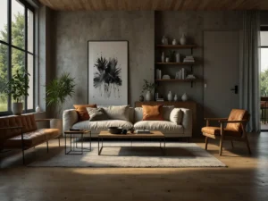
Una casa fatta su misura non è un catalogo ben composto: è un racconto di gesti, misure, materiali e luce che ti assomigliano, stanza dopo stanza.
Perché il su misura conta davvero
Arredare non è solo scegliere colori. È un processo che unisce misura e identità. Con l’arredamento su misura progetti spazi che rispondono a ciò che fai ogni giorno. Non a un’idea astratta di bello.
Esempio concreto. In un bilocale stretto ho inserito una panca contenitore profonda 40 cm sotto la finestra. Ha risolto tre cose: seduta, storage per biancheria, piano per piante. Nessun mobile standard reggeva il confronto in quella nicchia. I mobili su misura nascono così: dall’osservazione dei margini e dei vuoti.
Dati utili guidano scelte sobrie. Per il piano di lavoro in cucina l’altezza standard è 90 cm, ma puoi variare tra 85 e 95 cm in base alla statura. Il “triangolo di lavoro” tra lavello, piano cottura e frigo funziona se la distanza totale sta tra 4 e 7 metri (linee guida NKBA). Per passaggi comodi considera almeno 90 cm liberi. Per il desk in casa, una luce di 500 lux aiuta la concentrazione (rif. UNI EN 12464-1 per postazioni di lavoro).
La qualità dei materiali conta. Pannelli a bassa emissione di formaldeide in classe E1 (EN 717-1) garantiscono limiti sotto 0,124 mg/m³. Il legno certificato FSC o PEFC assicura filiere tracciate. Scelte così migliorano aria e durata, oltre alla sostenibilità. Il World Green Building Council segnala che luce naturale e ventilazione incidono su benessere e performance: non è solo estetica, è salute.
E qui il punto centrale. Il vero “su misura” non è l’estetica perfetta. È progettare intorno ai tuoi rituali. Sveglia lenta con tazza in mano? Prevedi una mensola a 110 cm vicino alla finestra. Abiti lunghi? L’armadio deve offrire 120 cm di appenderia in altezza. Collezioni vinili? Servono ripiani da 33,5 cm di profondità. Il progetto d’interni nasce da misure di vita prima che da misure di parete.
Strumenti pratici e un po’ di coraggio
Fai un inventario d’uso. Elenca 10 azioni ricorrenti in casa. Disegna attorno a esse. È il tuo brief di interior design su misura.
Mappa le criticità. Spigoli, nicchie, pilastri: lì il su misura vince. Una libreria “a quinta” può schermare l’ingresso senza chiudere la luce.
Scegli finiture oneste. Rovere oliato, linoleum, microcemento: tattili, riparabili, coerenti con la manutenzione.
Prova prima di fissare. Sedia, altezza mensola, maniglia: una settimana di mock-up in cartone vale più di cento render.
Illumina in strati. 2700–3000K per ambienti serali, accenti orientabili su tavoli e opere. Le strip LED nelle gole dei mobili su misura risolvono ombre senza invadere.
Budget e tempi. La falegnameria artigianale offre controllo e riparabilità. I costi variano per essenze e ferramente: chiedi scomposizioni chiare (corpo, frontali, ferramenta, posa). Se non trovi dati certi sui tempi di consegna, meglio segnalarlo e fissare milestone verificabili per fasi.
Piccolo aneddoto. In un corridoio di 95 cm, una boiserie da 12 cm con nicchie portaoggetti ha trasformato un passaggio in “stanza di mezzo”. Un oggetto quotidiano trovava posto all’ingresso. Il cliente ha smesso di accumulare sul tavolo. Era quello il valore: ordine che non chiede sforzo.
Pensa a una linea di luce che scivola sul legno la mattina, e a un pomeriggio piovoso in cui il divano abbraccia bene la schiena. Se la casa ti invita a restare e a partire con la stessa naturalezza, forse hai già centrato il tuo vero stile personale. Qual è il gesto che vorresti vedere, domani, trovare posto tra le tue cose?